
 |
| Wilderlands - Land Trade Radius |
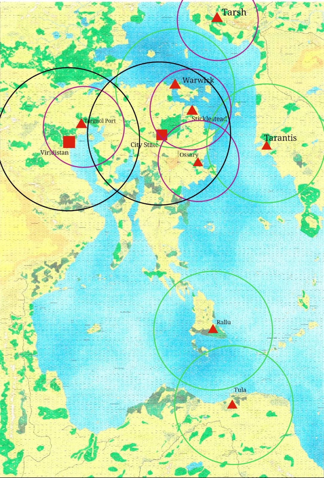
In the first diagram I have entered the locations of the largest settlements and drawn the radius of land trade routes for each. The radius comes form the Adventurer,Conqueror, King rules -AFAIK, the only system to tackle trade in a systemic way. Shown are every settlement with over 2500 inhabitants - there's only ten.
Drilling into the the area of the City State and Viridistan, which is the only area where city states are close enough to have mutual boundaries, I come up with this diagram. Besides the land trade radius, I have now added political boundaries.
Further posts will cover actual trade routes, including laying out additional roads; sea trade; and thoughts on the social structures of the Wilderlands.
The circles represent the approximate maximum distance of trade via a road from the settlement.
Black circles are the largest, they show the trade radius for Class I Markets [Population >= 20,000], limited to Viridistan (City State of the World Emperor) in the west and the City State of the Invincible Overlord in the center.
Green circles show the land trade radius of Class II Markets [Population >= 5,000]: Tarantis in the east, Warwick north of the City State, Rallu and Tula in the south.
Purple circles surround Class III Markets [Population >= 2,500]: Tarsh in the north, Targnol Port in the west and Sticklestead and Ossary east of the City State.
For a bidirectional trade route to have a chance to exist, the circles need to contain both settlements. See for example Targnol Port and Viridistan. If only one of the circles contains both cities, then no trade route exists, see the City State and Ossary.
We have only four potential land trade routes, Viridistand/Targnol Port; City State/Warwick; City State; Sticklestead and Warwick/Sticklestead.
More about this in later posts.
More about this in later posts.
Drilling into the the area of the City State and Viridistan, which is the only area where city states are close enough to have mutual boundaries, I come up with this diagram. Besides the land trade radius, I have now added political boundaries.
 |
| Wilderlands Political Boundaries |
Viridistan and the City State are the big dogs of the continent, as such, the smaller city states - especially Warwick, have been quite constrained in their boundaries. Despite Warwick being the only Class II Market on this map, it actually controls less land area than any of the Class III Markets. The Rorystone Road and the Dwarven Kingdom of Thunderhold, long an ally of the City State keeps it from expanding west of Demon Tongue or south of the River Stillring. Port Targnol is a wholly own subsidiary of the Green Emperor in Viridistan. Probably ruled by the descendants of a former royal house, as canonically there isn't anyone left but the Emperor and Empress in the current royal house - he was extraordinarily thorough in removing potential rivals.
The reddish area in the middle, Battleplain Gwalion, shows the conflicting claims between the two city states. The City State claims west to the River Bucknol and Grimlon Outlands, then south through the Buskin Wood to the Romillion Sea. Conversely, the Emperor asserts his claims all the way east to Ered Cantrif, then south to the River Wakeful from the Falls of Barzani to it's mouth. In practice the Overlord maintains a line of fortresses from Keystone Peak to Lakenheath on the northern edge of the plains and Viridistan rarely pushes patrols east of the Crossing of Quoth, although tax collectors from both sides plague the villagers in the disputed area.
Further posts will cover actual trade routes, including laying out additional roads; sea trade; and thoughts on the social structures of the Wilderlands.
Excellent work, and a great goal. Trade is often hand-waved in FRPGs.
ReplyDeleteThe Necromancer Games version of the CSIO has a population of 80,000 (20,000 able bodied). Assuming the same 4:1 scaling for all population numbers, how would that change the trade radii?
ReplyDeleteNo change for the City State itself, but the villages would scale up into towns. Warwick, Osssry, etc would expand to the same trade radius as the City State.
ReplyDelete