
Ridiculously easy
In the previous post, I had finished editing out all of the roads and labels leftover from the screenshot I had taken in Google Maps. I want a hex map, I came up when players still bounced routinely between RPGs and Avalon Hill or Strategy and Tactics' board games, all of which were overlayed with a hex grid. I 've tried generating hex grids on computers for thirty years with varying results. Here I go again.Start by saving the map as a GIMP *.xcf, that way even if you screw up down the line, there's a back up of all that work you put in to clean up the terrain. With the xcf file, I'm going to add layers, that way if I put a town in the wrong place, I won't have to re-edit the terrain. To do that, press Control-L to bring up the Layer dialog.
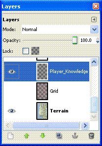
I've gone into the Layer Properties and renamed the first layer as 'Terrain', and created two additional layers 'Grid' and 'Player_Knowledge'. I'll use the latter to control what shows up on any maps I provide to the players. The little eye icons, control visibility of the layer, 'Grid' is currently invisible. The highlighted layer indicates which one you are currently editing.
As expected the page icon in the lower left is used to create a new layer.
So, how about that grid. I did a quick Google search in the expectation that someone, somewhere had not only wanted to use GIMP to make a hex grid, but had published direction on how to do it. What I found was a GIMP 'Script-fu' to do it for me - Hex Grid. Follow the instructions to install the script, then select your Grid layer and Filters->Render->Pattern->Hex Grid.

Here's the map from Apollonia to Oricum at 1:1 scale. I'm also showing the Player_Knowledge layer with the cities and major roads. Oddly, to me anyway, each name is treated as a separate 'mini-layer' by GIMP, so looking in the Layer dialogue you will also see Layers for 'Apollonia' and 'Oricum'.

As I said at the beginning it's ridiculously easy to add a hex grid in GIMP for tracking overland travel. In a subsequent post I'll cover how I sited the cities, and start generating smaller communities on a 'Small_Town' layer.
No comments:
Post a Comment