-->

Thursday, April 23, 2020

Wilderlands - Give Me a Home, Where the Barbarians Roam

Barbarian Altanis are nomadic tribesmen who roam the lands of their more advanced ancestors.  Initial Guidelines Booklet I.

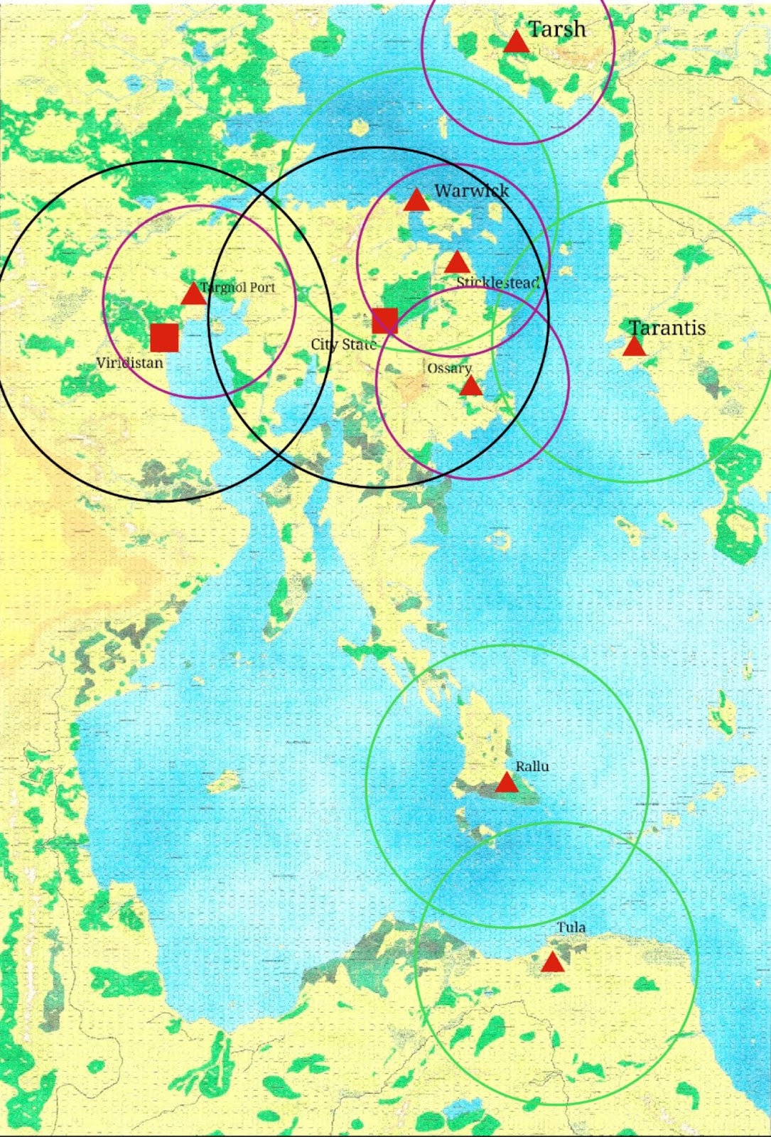
     After laying out the CSIO Market Area and boundaries, looking at the number of villages, castles and citadels on Map 2, I developed a strong impression that there isn't sufficient unclaimed areas to support tribes of nomads.   Rob Conley, in his revision of Wilderlands, assures us that there is plenty of room to fit the nomads in.  Let's see for ourselves.

 
Altanis Village Market Areas
Click for full size
     The first step is to layout the Market Areas for all of the villages on Campaign Map 2.  Technically, they are all Market Class VI in ACKS with a twenty five mile maximum.  (That would only come into effect if the village was located on a road, which only one is, so almost all borders have been shortened using the MP costs from the previous post. )  But Antil is less than seventy inhabitants below the cut off for Market Class V, they exist in a strategic position for shipping on the Romilian Sea - and I was bored with the small areas, so I used the larger area for it.

As can be seen in the Altanis Village Market Area map there is very little area outside the Market Area (the multicolored lines and shaded areas) of some village or another. And I haven't even looked at Barony patrol areas yet.

    Thinking over the image, I decided that it is unrealistic to assume that every hex in the Market
Altanis Village Neighborhoods
Click to enlarge
Area is under continuous occupation or observation by the villages; which would preclude or at least discourage nomads from wandering through.  I decided to reduce the footprint of the villages to their immediate neighborhood, where the fields and pastures worked on a daily basis would be found.  The outer areas are analogous to what Warhammer Fantasy Roleplay refers to as 'Zones of Dependency' where isolated farmsteads, mining claims and natural resources, such a salt licks are to be found.  [Note:  Settlement patterns in WFRP's 'Old World' setting are nothing like Wilderlands, but concept of scattered holdings around the village makes sense.]    This produced the Altanis Village Neighborhood map, where the blue lines show the area surrounding each village that is under daily use.  

Plenty of room for nomads now!  OK, I need to add in the areas patrolled around the castles and citadels, as I don't see a feudal knight allowing a bunch of barbarians to chase a herd of mammoths through his serf's wheat fields.

Per the original Wilderlands of High Fantasy

BARONIES

Upon building a stronghold, player-characters must clear every four hexes (five miles each) radiating from the hex in which his stronghold is located.  While clear terrain can be maintained monster free by patrols, mountains, swamps and dense wood hexes cannot be maintained clear of monsters.  For this reason barons do not usually patrol these areas, prefering [sic] the more tillable clear terrain and hilly areas.

Altanis Villages and Patrolled Areas
Click to enlarge
In this case, I did not reduce the patrolled area by terrain costs, but I did end the patrolled areas at the terrain features listed.  For the most part, as there are a couple of citadels smack in the middle of jungle hexes that would be patrolling something.  In counting off the hexes from each citadel, I have come to suspect that there was some effort made in placing them, as the patrol areas for neighboring citadels usually abut or overlap by no more than a hex.  Rather than laying out these overlapping areas, I chose to map the continuous areas patrolled by the citadels with it.  That brings us to the red lines and shading on Altanis Villages and Patrolled Areas.


Other than the Eyestone Jungle on the east coast, there isn't much that isn't patrolled.  The Lagoldurna Jungle to the east has a string of villages cutting it in half restricting the range of any nomad tribes.

    So, there's no room for nomads in Altanis.  Well, not if you assume a feudal society around the strongholds.  In my next post, I'll cover putting the barbarians back in Barbarian Altanis along with some notes on the barbarian nations to be encountered at the players peril.

Friday, April 17, 2020

Wilderlands - City State Market Area

I realized after my last post that what ACKS considers the distances involved in trade routes, really don't reflect real world trade distances.  While the Spanish treasure armadas and Dutch spice trade are post-medieval examples, albeit still limited to wind and muscle technologies, the Silk Road shows the the flow of long distance trade as does the Roman Indian Ocean trade even earlier.  In fact, very long distance trade evidence goes back into the Bronze Age.

With those observations in mind, the ACKS trade rules do, I think, provide a useful scale for Market Area.  That is, the locations from which a city draws immigrants, as well as natural and agricultural resources and to which it regularly exports both it's own manufactures and items  obtained from trade outside the Market Area. 

Spherical Cows of Uniform Density
     One of the comments I received about the previous post was that the circles denoting trade routes were unrealistic.  Which is quite true, I just wasn't prepared to tackle it in the first post.  The circles defined the outer limits of trade in a perfect world where we assume roads run on flat plains in every direction, which the maps show to be a false assumption.   So lets start refining those assumptions.

ACKS lists Range of Trade (Roads) for Class I Markets as having a maximum distance of 168 miles or 28 six mile hexes.  The comes to 33.6, round it up to 34, five mile hexes from the Wilderlands maps.

Assumption:  This Range of Trade is for travel on a road.  That is a patrolled and maintained pathway which has features, such as bridges, cuttings, ferries, etc to facilitate travel across natural obstacles.  Off road travel distances are shorter.

ACKS Movement Multipliers
TerrainMultiplierTrade RangeHexes (Wilderlands)
Road or Clear Wide Trail*3/2168 miles34
Plains*1112 miles22
Desert, Hills, Woods*2/375 miles15
Jungles, Swamps, Mountains*1/256 miles11

All well and good, except that I need to handle trade routes crossing all of the terrain types.  So I'm going back to my roots in counter and hex war gaming and converting things to Movement Points.  Land based trade routes are 34 Movement Points in length, they spend MPs according to the following table.

Trade Route Terrain Movement Point Costs per hex
TerrainWith RoadWithout Road
Plains13MP every 2 hexes
Desert, Hills, Woods3MP every 2 hexes
Jungles, Swamps, Mountains2

     After installing Crouton and GIMP on my Chromebook, and converting the maps from PDF, plus a few hours of counting hexes - probably not completely consistently - here's the boundaries (black lines) and Market Area (red overlay) for the City State of the Invincible Overlord.

Click to Embiggen

Sunday, April 12, 2020

WIlderlands Land Trade Radius and Political Boundaries

        Wilderlands - Land Trade Radius
I started out doing an analysis of land trade routes to determine economic spheres of influence.  I quickly ended up doing political boundaries.  The two are certainly linked in the real world, however I don't provide a segue between them so this post is a bit disjointed.

In the first diagram I have entered the locations of the largest settlements and drawn the radius of land trade routes for each.  The radius comes form the Adventurer,Conqueror, King rules -AFAIK, the only system to tackle trade in a systemic way.  Shown are every settlement with over 2500 inhabitants - there's only ten.

The circles represent the approximate maximum distance of trade via a road from the settlement.

Black circles are the largest, they show the trade radius for Class I Markets [Population >= 20,000], limited to Viridistan (City State of the World Emperor) in the west and the City State of the Invincible Overlord in the center.

Green circles show the land trade radius of Class II Markets [Population >= 5,000]: Tarantis in the east, Warwick north of the City State, Rallu and Tula in the south.

Purple circles surround Class III Markets [Population >= 2,500]: Tarsh in the north, Targnol Port in the west and Sticklestead and Ossary east of the City State.

For a bidirectional trade route to have a chance to exist, the circles need to contain both settlements.  See for example Targnol Port and Viridistan.  If only one of the circles contains both cities, then no trade route exists, see the City State and Ossary.  

We have only four potential land trade routes, Viridistand/Targnol Port; City State/Warwick; City State; Sticklestead and Warwick/Sticklestead.

More about this in later posts.

Drilling into the the area of the City State and Viridistan, which is the only area where city states are close enough to have mutual boundaries, I come up with this diagram.  Besides the land trade radius, I have now added political boundaries.
Wilderlands Political Boundaries

Viridistan and the City State are the big dogs of the continent, as such, the smaller city states - especially Warwick, have been quite constrained in their boundaries.  Despite Warwick being the only Class II Market on this map, it actually controls less land area than any of the Class III Markets.  The Rorystone Road and the Dwarven Kingdom of Thunderhold, long an ally of the City State keeps it from expanding west of Demon Tongue or south of the River Stillring.  Port Targnol is a wholly own subsidiary of the Green Emperor in Viridistan.  Probably ruled by the descendants of a former royal house, as canonically there isn't anyone left but the Emperor and Empress in the current royal house - he was extraordinarily thorough in removing potential rivals. 

The reddish area in the middle, Battleplain Gwalion, shows the conflicting claims between the two city states.   The City State claims west to the River Bucknol and Grimlon Outlands, then south through the Buskin Wood to the Romillion Sea.  Conversely, the Emperor asserts his claims all the way east to Ered Cantrif, then south to the River Wakeful from the Falls of Barzani to it's mouth.  In practice the Overlord maintains a line of fortresses from Keystone Peak to Lakenheath on the northern edge of the plains and Viridistan rarely pushes patrols east of the Crossing of Quoth, although tax collectors from both sides plague the villagers in the disputed area. 

Further posts will cover actual trade routes, including laying out additional roads; sea trade; and thoughts on the social structures of the Wilderlands.

Wednesday, April 8, 2020

Real-life Hexcrawl Manual

Randolph Marcy by Matthew Brady,
Courtesy Library of Congress, Public Domain
     About 30 years ago, on a Permanent Change of Station from San Diego to New York City, we traveled via Old Fort Laramie on the Oregon Trail.  Not much left but some foundations being cleared by archaeologists, a nice diorama and a gift shop.  Oh, and the wagon ruts left by travelers over a century in the past.  Have the Polaroid of the boys standing in them somewhere.  My souvenir was a reprint of Captain Randolph Marcy's guidebook The Prairie Traveler - it turned up today when I was looking for something else.

     Captain Marcy was an experienced frontier hand with the pre-Civil War US Army.  In 1859, he published his travel guide for settlers, providing them with information on the routes to the west, practical tips on overcoming obstacles like rivers and broken wagons.  How to tell if the horse tracks were a group on Indians moving their lodges, on a hunting or war party or just wild mustangs, snake-bite remedies, how to pack mules and make a horse stretcher, etc, etc and may I say etc yet again.  In less than 300 pages, with illustrations, he packaged up as much knowledge as he could to keep the migrants alive across the prairie and mountains.

     What catches my eye now, because of some posts I'm working on concerning the Wilderlands trade routes and boundaries, is that he includes itineraries for a number of routes.  Stop by stop distances, descriptions and information about forage, wood and water.  In gaming, most systems assume that overland travel proceeds at a constant rate day over day - and on average you can say that.  However, the rates of movement are based on the speed of the mount or walker, with a multiplier for terrain that increases or more usually decreases the daily movement - generally about 25 miles/day when mounted.  In reading through the actual itineraries, and doing some back of the envelope calculations, I find that the average journey between camping spots was 14-16 miles.  But depending on the availability of forage, wood and water, any given leg of the journey varied between 2 and 52 miles.  In hindsight, it's obvious "Professionals study logistics" - a hexcrawl should  take this into account.

Questions and Notes:
     How accurate are the distances given?  Pre-Civil War West Point education was very civil engineering and land survey oriented.  One of the lessons of the Napoleonic wars that the European militaries had picked up and transmitted in the writings of von Clausewitz and Jominie to America, was the importance of accurate knowledge of the terrain.  Indeed in reading about the Civil War generals, it's remarkable how many of them had left service to work on the railroads where their knowledge was critical in driving the rail lines through as cheaply as possible.

    Horses vs Oxen - he addresses both, as well as mule teams, but the itineraries do not differ based on your choice of draft animals.  Again, the logistics of where you can stop determines how far you will travel, you just might take an hour longer to get there.

    Could an ox team really go over 50 miles in a day?  While that's the first impression, I think it's a bit erroneous.  The itineraries aren't really explained well, almost all of the stops are less than 25 miles apart, 8 hours at 3 MPH pretty much gets you there in a single day.  But in a separate section, he talks about how to cross long distances between campgrounds like the 78 mile Journado del Muerto in New Mexico.  There the journey is done over two nights, there simply isn't any place to camp and there may not be water.  He recommends traveling at night, resting the animals every couple of hours, longer the second night.

Wednesday, April 1, 2020

Corona Quarantine - Chivalry & Sorcery Edition

     So I wrote a Chivalry & Sorcery 1e character generator (NPC at least) using Google Sheets.  Having finished it, I can safely state that this belongs in the 'hold my beer' category of actions.  Yes, you can, it seems like a good idea at the time and you finish thinking 'What did I just do?'   Not that writing a character generator is a bad thing, even for such an old system.  Especially one that is as crunchy as C&S in terms of conditional recursion - IQ impacts Wisdom, which impacts IQ and doing a whole bunch of lookup tables in order to calculate the characteristics.

   In order to calculate Personal Combat Factor, I needed to determine the character's class or
vocation.  That was probably the most creative part of it - it's not just that you're strong and a good fighter.  Only Nobles get to be Knights and Serfs need to be exceptional to come to the attention of a Magic User and get apprenticed.  Conversely, it's very rare to see a first born Noble become a Magic User, they need to be very smart and a pathetic fighter, as even a poor fighter is more valuable to the  succession in the mind of a feudal noble.

     When a Magic User does get rolled up, you'll see the bottom of the Character Sheet show the Concentration Level, Personal Magic Factor etc.

Anyway the link is here if you want to play with it.