-->
Showing posts with label Judges Guild. Show all posts

Saturday, November 7, 2020

Ten Strike Mine

      Needed an abandoned mine for an adventure, so thought I'd give the cavern generation rules from Wilderlands a spin.  Going to say I'm not impressed, with a 10% of the tunnel ending each roll the mines are quite small, especially as there is only a 5% chance of a branch or cross tunnel to generate alternate paths.  Caverns are encountered, but there are no rules for generating multiple exits from them.  As short as it is, it will work for the adventure I'm working on, but the Random Dungeon rules from the AD&D DMG are better.

Ten Strike Mine


Tuesday, September 1, 2020

Feudal Wilderlands Part V - The Changing South


Great Fiefs of the Wilderlands

The Changing South

  The original treaties between the City State of the World Emperor and the Altanian tribes, copies of which are in the Invincible Overlord's archives, stipulated the Rivers Greyrush and Llobregather along with Queans Waste were the boundary between civilization and what the Virdii saw as barbarism.  Recent generations have seen the border pushed south and the ancient tribal lands of the Altanians given to nobles and adventurers as feudal holdings.  In addition to these changes, the ancient province north of the Llobregather was invaded and then given to the Skandik raiders as a feudal holding to provide a useful navy against other raiders, both Skandik and Tarantine.


Jarldom of Skandry  occupied for hundreds of years by Skandik raiders before the Invincible Overlord reached an accord with Jarl Sigvids in Ossary, in return for his fealty in suppressing new arrivals to the Pagan Coast, Sigvids became the acknowledged ruler of the Duchy of Mill Haven, now usually referred to as Skandry.  In doing so the Jarl gained dominion, not only over the coastal strip the clans already held, but all the lands east of Ered Losthain between the River Torn and the Llobregather.
   The land ceded to the Skandiks run from the mouth of the River Torn upstream to it;s source then across the hills to the source of the eastern tributary to Archlin Stream and down to the frist tributary from the mouth (hex 3925). Up the tributary to it's source (hex 3826) along the hills through Neuwag's Neck (hex 3527) to Ered Losthain (hex 3428).  Down the crest of Ered Losthain through Fatherhorn Mountain (hex 3431) to the source of the River Llobregather (Map 2 Hex 3503) then down the river to it's mouth and back north along the cast to the mouth of the River Torn.  It also includes the minor islands at the mouth of Dolphin Bay.


   County of Zotheim  when the Invincible Overlord gave Mill Haven to the Skandiks, he compensated the Virdii Crispa family, who were the original Dukes, with a new holding carved out of the territories of the Altanian tribes. They dominate the Old South Road from their great keep at Bellystone Ford and are  granting fiefs to adventurers who they feel can deal with the resentful Altanians wandering through the new croplnads - and who will support them against the Skandiks when the time comes.  Rumors of Imperial galleys in Zothay abound, the Count is looking for a strong ally to counter the Jarl's ships.
   Zotheim's boundaries start at the source of the Llobregather (Map 2 Hex 3503) and continue down stream to the coast, south along the coast to the Fogbound Forest,  along it's northern bound to the foothills of Ered Perack (Map 2 Hex 2913), then jogging north (Map 2 Hexes 2911, 3010) along the crest of Ered Perack until it meets the Cloudwall Mountains by the edge of Queans Waste (Map 2 Hex 3004).  Northeast along the crest of the Cloudwalls past the source of the Greyrush (Map 2 Hex 2801) the edge of the Hetflas Dunes (Map 1 Hex 2734 ), then east along the edge of the dunes and Queans Waste to Ered Losthain (Map 1 Hex 3433) and back south to the source of the Llobregather.


Altanian Marches - the vast area south of Greyrush and the Llobregather were added to the lands of the City STate of the Invincible Overlord through treaties with Altanian chieftains, merchant traders, eager adventurers and finally outright conquest pushed the more or less controlled border south to the River Endgate, past Bludgeon Peak, across the northern tributaries of the River Farhills and over to the Bay of Trespasses.  The Invincible Overlord claims the rest of the peninsula, but no one living there cares or has seen a soldier or tax gatherer.  The Overlord rules here directly through his favorites.  Adventurous courtiers compete for an assignment to rule a fief for five years in the hopes that they can make it hereditary - or at least a lifetime benefice.
  The northern boundary is the Greyrush, Cloudwalls and Ered Perack down to the Fogbound Forest, the entire peninsula between them and the Endgate to Bay of Trespasses line described above is considered and taxed as part of the Marches.  In addition to scattered benefices, towns and villages there are numbers of "wild" Altanian tribes who do not acknowledge the change in ownership.  A wise fiefholder is ready to trade with them as they cross his or her lands in exchange for leaving the crops and cattle alone.


This ends my regional write up of the Feudal Wilderlands.  Next I intend to do detailed write ups of the individual provinces.

Thursday, August 27, 2020

Feudal Wilderlands IV - The Imperial West

Great Fiefs of the Wilderlands

The Imperial West

The western provinces of the City State of the Invincible Overlord border the lands of the City State of the World Emperor and are places of trade and intrigue as Imperial Satraps attempt to gain influence, allies and treasure.


County of Saule - ruled by a branch of the Skandik Sigvids, who traded their ships for horses, the vales of the county (Willowmead, Silverwood, Rathold and to a lesser extent the Chaos Nest of the Carrion Abyss) are the breeding places of the best mounts.  Mostly horses, but pegasi and griffons are found in the Majestic Mountains and trained in Rathold, and Abyssal worgs are the gold standard of goblin cavalry.  The Trade Road from the City State to the Empire crosses the southern edge from the Werewood Crossing to Grita Heath in the Empire.  

     Saule's borders run from the Carrion Abyss in hex 1808 east passing over Sabre Scarp to the crest of the Majestic Mountains, thence south west along the crest of the Majestics and the hills to their southern outlier in hex 1613.  The border runs from there southeast to the Rorystone River, thence downstream to Council Lake, along the northern lake shore, then up the River Briskly and the Gnarith to it's source.  From the source of the Gnarith, the border goes northeast to the headwaters of the Syfwitch.  It follows the Sywitch downstream to the confleunce of it's tributary(hex 1307), then southeast along the crest of the hills and mountain south of Harridrim Cap to Carrion Abyss. 


County of Tungraine - the Wilderlands version of Kansas, the county is dominated by the flat Swarthlad Plains and has been ruled by the Virdii Maximian family for over  1000 years.  Located in the center of the continent, it is crisscrossed by irragation channels from it's bounding rivers.  The Trade Road crosses from Gaehill to Werewood Crossing; Battle Road runs from Haghill through the edge of Gwalion towards Spingle tand he the Crossings of Queth.

     The boundaries start at Council Lake, following the north shore from the mouth of the Briskly to the mouth of the Rorystone, then upstream to a point (hex 1814 ) between the southern outlier of the Majestic Mountains and the source of the River Stillring.  East from that point to the crest of the Howling Hills.  Thence south along the Howling Hills to the headwaters of the Eorlbane in hex 2121, on to the headwaters of the river defining the northern boundary of the Mermist Swamp in hexes 2122 and 2123 and then to the headwaters of the northern fork of the southern river defining the Mermist Swamp.  It follows that river down to the central tributary, up that stream to it's source (hex 2126), south across Twinhorn Pass to Ered Cantref (hex 2128).  Northwest from Ered Cantref through Keystone Peak to the edge of Battleplain Gwalion (hex 1725), from there the border follows the northern edge of Gwalion until it reaches the source of the tributary to the River Buckol (hex 1124).  It follows the tributary downstream until it joins the Buckol in the Smokewood Fens, then the Buckol from the Fens to Council Lake and back along the southwestern lake shore until it reaches the mouth of the River Briskly.


County of Gwalion - a land the Sages Guild considers to be a boiling pustule of space, time and planar magics, Gwalion is ruled by a powerful, mysterious wizard who claims to be a Skandik named Hranfast.  Or at least it is said to be so.  It is also said that the Count has sworn allegiance to both the Emperor and the Overlord ... as well as to more malignant beings from across the cosmos.   Despite this there are peasants working the land, who usually look human.  They say that as long as you keep the animals and your family inside when the sea green fog covers the land. 

     The Battle Road runs across the northern edge, heavily fortified and infrequently traveled.  Shorter than the Trade Road, the instability of Gwalion has swallowed and disgorged armies along the Battle Road.  Adventurers have reported a sky with two suns and strange colored humans with unspeakable magics; great living demonic machines fighting; red deserts with strange six legged beasts and other prodigies.  Some, like the Fladhal, Blessed Foreman of Hephaestus in Anvil have been said to have recovered powerful artifacts from Gwalion;  while most simply never return.   

     Battleplain Gwalion defines Gwalion.  More technically, the border passes northwest from Ered Cantref through Keystone Peak to the edge of Battleplain Gwalion (hex 1725), from there the border follows the northern edge of Gwalion until it reaches the source of the tributary to the River Buckol (hex 1124).   Southwest along a straight line towards the source of the Elvenstar, but trending away to the east at hex 0927 to follow the southern border of Gwalion to hex 1828, from where it jogs back to Ered Cantref.


County of East Romilia - the City State's gateway to the Romilian Sea, this province controls the coast and the Lanshan Gap Between the Cloudwall Mountains and  Ered Cantref.  The northern area is one of frequent battle grounds between the hosts of the Invincible Overlord and those of the World Emperor, the old province of Romilia having split in two when the City State was first able to throw off direct rule by the World Emperor.

    East Romilia's boundaries coincide with Gwalion's southern boundary, From where Gwalion trends away (hex 0927) from the straight line between the sources of the Elvenstar and the tributary of the Buckhol, following the southern border of Gwalion to hex 1828, from where it jogs back to Ered Cantref.  South from Ered Cantref across Lanshan Gap then southeast along the crest of the Cloudwall Mountains to the source of the River Greyrush (Map 2, hex 2801).  Down the Greyrush to it's mouth, north along the cost to the mouth of the Elvenstar.  Upstream to the source of the Elvenstar, then back to the northeast along a straight line to the headwaters of the tributary of the Buckhol to where the line intersects the edge of Battleplain Gwalion.


Previous Posts in this Series

Wednesday, August 19, 2020

Feudal Wilderlands - Part III - The Restless North

Great Fiefs of the Wilderlands

The Restless North

    The northern coastal provinces  (barely coastal in th case of the Dwarven subkingdom of Thunderhold) have some of the most tenuous relationships to the Invincible Overlord.  In the case of Thunderhold, the dwarven king pays homage to the Overlord, but promotes trade with his most dedicated enemies - both Gwarenne and the City State of the World Emperor.  Gwarenne is notoriously independent, dominating trade with Valon and the Elphand Lands, Valley of the Ancients and controlling the most direct sea route to the City State of the World Emperor, giving it economic clout to resist the Invincible Overlord.  Vinnior is a narrow windswept coastal plain on the backside of the Majestic Mountains, it's inhabitants are considered to be the most rustic and boorish of all the City State's provinces.


 Duchy of Gwarenne - ruled by the illustrious Sana family, who where among the original conquerors and colonists from the City State of the World Emperor over 1000 years ago.  This fief is ruled more as a rival to the City State of the Invincible Overlord, rather than as an inferior.  It's boundaries start at the confluence of the central tributary of the Stillring in hex 2511, it follows the Stillring to it's mouth in hex 3110, then turns north and follows the coast around the Wormshead peninsula to hex 2904, then due south to the mountains east of Demon Tongue, turning generally south west along the crests of the hills and mountains to hexes 2607 and 2608, south southwest back to the confluence of the central tributary of the Stillring in hex 2511.  It also includes Brezal Isle.


County of Rorystone and Kingdom of Thunderhold - ruled by the Dwarven Iron-helms.  The Dwarven Kingdom of Thunderhold has been, for years, a major trading partner of the City State of the Invincible Overlord.  In the files of the Litigation Trickster's Guild and the various courts of the City State, it has acquired a dual character.  The ruler is still King of the Dwarves, but is also legally the Count of Rorystone ruling the humans above ground, one of the few rulers acknowledged by more than one race.  As the Count he pays homage to the Overlord in return for the rights to collect tolls on Rorystone Road.
     It's boundaries start at the confluence of the central tributary of the Stillring in hex 2511, generall north northeast to the crests of the hills in hexes 2608 and 2708, then generally northeast along the crests of the hills and mountains to the mountains east of Demon Tongue. Due north from the there to the coast in hex 2904, west along the coast for ten miles to the deepest point of the bay in hex, then west to Nimbus Tor.  From Nimbus Tor it tends southwest along the edge of the seaward slopes of the Majestic Mountains to through mountains in hex 2106 to the Carrion Abyss in hex 1808.  Turning east it passes over Sabre Scarp to the crest of the Majestic Mountains, thence south west along the crest of the Majestics and the hills to their southern outlier in hex 1613.  The border runs from there southeast to the source of the River Stillring, then back up the Stillring to it's confluence with it's central tributary.


County of Vinnior - ruled by the Seighard family. Once powerful chieftains in Altanis, they were elevated to the major nobility and exiled to this cold and windy land far from their southern home and kinsmen.   They have little in common or respect for the mostly Tharbian peasants native to the land.  This rustic backwater consists of the small coastal plain, dominated by the north wind off the Winedark Sea, where the population practices subsistence farming and fishing.  The hills and slopes on the far side of the Majestic Mountains and nearby ranges provide grazing for sheep and goats as well as a source of monster parts for magic users through out the region.
     Vinnior's boundaries run from the deepest point of the bay in hex 2803 west to Nimbus Tor.  From Nimbus Tor it tends southwest along the edge of the seaward slopes of the Majestic Mountains to through mountains in hex 2106 to the Carrion Abyss in hex 1808.  From Carrion Abyss it runs generally northwest along the crest of the hills and mountain south of Harridrim Cap to the tributary of the Syfwitch River in hex 1307, down the stream to the Syfwitch and down the Sywitch to it's mouth on the Winedark Sea.  It turns back along the coast to the east to the deepest point of the bay in hex 2803.


Previous Posts in this Series

Thursday, August 13, 2020

Feudal Wilderlands Part II

     This portion of the series will concentrate on defining the boundaries of the independent fiefs, name the noble family that rules it and add my initial observations of the area.  I intend (and we all know what's paved with good intentions) to do fief by fief posts adding detailed information about the fiefs and their sub-demesnes.    In short this is a work in progress allowing me to flesh out a great many details about the Wilderlands using Chivalry & Sorcery as the game system.  Note that I am currently being influenced by Merovingian Francia in my concept of the politics of the Wilderlands.  Not independent cities, but no strong central authority either. 

  The Great Fiefs of the Wilderlands 

The heartland along the Roglaroon

    These are the core of he provinces claimed by and usually acknowledging the Invincible Overlord.  They are loyal to the City State due to the shared trade highway of the Estuary of the Roglaroon.  The fact that they're also the easiest for the Overlord to send and support a Vasthost when putting down dissent and rebellion may play a factor in their overt professions of loyalty.

The City State - the personal demesne of the Invincible Overlord.  It's core is the City State and the rich farmland to the west, but contains the Moonraker Moorlands as well as the Troll Fens and Mermist Swamp.  It claims much of the Dearthwood, but those claims are subject to dispute by the Orcs of the Purple Claw.  
     It's boundaries start where the Forest River enters into the Roglaroon in hex 3518, follows the river upstream along the northern branch to hex 3017, south to the headwaters of the tributary of the Conqueror's River in hex 3018, down that stream to it's confluence with the Conqueror's River then upstream on the Conqueror's to it's headwaters in hex 2714, continuing across to the headwaters of the river Stillring and it's tributaries in hexes 2613, 2314 and 2014.  Thence south along the Howling Hills to the headwaters of the Eorlbane in hex 2121, on to the headwaters of the river defining the northern boundary of the Mermist Swamp in hexes 2122 and 2123 and then to the headwaters of the northern fork of the southern river defining the Mermist Swamp.  It follows that river down to the Roglaroon and along the estuary back to the start on the far side of Dearthwood.


County of Severnais - ruled by the Catilia family of Virdii extraction.  The coasts and banks of the estuaries cutting this demesne are high and steep, making water transport much harder than the you might expect from the map.  Small fishing and smuggling settlements exist, but no major ports.  
     The demesne follows the boundary of Roglaroon from it's beginning at the mouth of the Forest River in hex 3518, all the way through the headwaters of the River Stillring in hex 2014.  From there it turns and follows the Stillring all the way to it's mouth on the coast in hex 3110, thence along the coastal hexes to the Mouth of the Roglaroon in hex 3712, then back up the estuary to the beginning.

County of Losthaine  Ruled by the de la Vora family from Antil, recent favorites of the Overlord.  The wide plain between the Cloudwall Mountains and Ered Losthain is an important agricultural area feeding the City State.  The fortress at Bier (hex 2926) not only protects the Old South Road and the ferry crossing, but also serves as a sheltered anchorage for vessels awaiting better wind and tide conditions to minimize their exposure to the hazards of the Estuary.   
    The county's border follows the Roglaroon from the mouth of the southern river draining the Mermist Swamp to the mouth of the minor stream east of Bier (hex 3124), up that stream to it's source on the slopes of the mountain (hex 3426), along the crest of the hills joining that mount to Ered Losthain proper (hexes 3127-3428).  Down the crest of Ered Losthain to Fatherhorn Mountain (hex 3431) , bending southwest along the spur to the south (hex 3333) then west along the edge of Quean's Waste and the Hetflad Dunes to the Cloudwall Mountains (hex 2734), turning northwest along the crest of the mountains to Lanshan Gap (hex 2129), across Ered Cantref and Twinhorn Gap (hex 2127) to the source of the central tributary (hex 2126) to the southern river draining the Mermist Swamp, back down that stream to it's mouth on the Rogalroon.


County of Brythange - Ruled by the pleasure loving Vespillia family, who emigrated from the City State of the World Emperor due to excesses too great for that decadent court some 800 years ago.  This realm is tucked along the southern bank of the estuary.  It's extensive forests (for it's size) are hunting preserves of the nobility, being generally safer than the Dearthwood across the water.  The fortunate peasants toil for their overlords on the central and eastern plain adjacent to the Hagrost.  The less fortunate have to toil in the rocky uplands of the west and south.
   The border starts at the mouth of the minor stream east of Bier (hex 3124), down the Roglaroon to the confluence of the river Hagrost (hex 3522), up the Hagrost to the first tributary of the Archlin Stream (hex 3925).  It goes up that tributary to it's sources in the hills (hex 3826), along the crest of the hills through Neuwag's Neck (hex 3527) to Ered Losthain (hex 3428).  It follows the crest of the hills north to the mountain east of Bier and the source of the minor stream (hex 3426), thence down stream to the mouth on the Roglaroon. 


Duchy of Difrios  Known as the loyal duchy, it's sobriquet is more a reflection of the Overlord's problems with the other Dukes than any fond feeling on the part of the debauched Vespillia family.  This is the family's major holding and the Dukes, who often privately style themselves Rex Modronia, have as much control of their relatives - including the infamous Rumps of Tegel - as the Overlord does of them.  The duchy is a prosperous province with many agricultural, mineral and raw material resources.  It also benefits from controlling the trade at the mouth of the Roglaroon, the city of Modron being a major transshipment point as well as the entrepôt for the goods of the province.  
   The border starts at the confluence of the River Hagrost and follows the Roglaroon down to it's mouth.  It controls the entire coast down to the River Torn (hex 5123).  The boundary follows the Torn up to it's source (hex 4424), then across to the source of the Archlin Stream (hex 4226) and down the Archlin and Hagrost back to the confluence of the Roglaroon.  Difrios also includes the isle of Croy and a number of smaller islands in the Winedark Sea within it's borders.


Wilderlands guides and maps are copyright 2018 Judges Guild.  They have been  used without express permission to illustrate my personal version of  the classic campaign setting.

Rob Conley, who did the Layout and Cartography for the Revised Edition, has  new a Kickstarter for his  RPG rules based on his long running campaign.

Wednesday, August 5, 2020

Feudal Wilderlands Part I

     Continuing with the series I was posting back in April and May, I am now ready to start designing a feudal version of the Wilderlands using the 'Designing the Feudal Nation' rules from Chivalry and Sorcery's old red book.  To recap, I've followed Chesterton's advice and studying the Wilderlands canon to understand how the pieces work together - now I'm ready to make changes to take my version to my version of the setting to add a richer background.


     Two things are required by C&S when designing a feudal nation - a map of the nation where you can draw the boundaries and the number of great nobles of varying denominations.  C&S recommends a King (the eponymous Overlord), 2-3 Dukes, 2-3 Marquises and about 10 Counts.   Now this doesn't really line up with the Social Level table from ready Ref Sheets, etc that are part of the Wilderlands canon.  

BOOM!  Down goes a fence.  As long as I'm using C&S, its Social Class system will be used including the calculated Basic Influence Factor or BIF.  If they interact personally with any of the gods running around in the Wilderlands - Baldur comes to mind - I'll adapt the C&S Social Class to the circumstances instead.

    Looking at the map and the canonical castles - including the one in Hex 4014 of Map 1 that isn't  listed in the Wilderlands campaign book; I've decided to start with three Dukes, twelve Counts and one Baron who hold their lands directly from the Overlord.  They will determine all the other feudal holdings, which will include the canonical castles and citadels as well as I expect a number of additional fiefs that I will need to place.

   One other design consideration is how strong is the Overlord?  C&S says a strong King, like most of the Plantagenets of England would have holdings equal to 2-3 dukes; while a weak King, like the later Carolingians and early Capetians of France would only be the equal of a duke.  The canon is mixed on this question, the discussion of hosts and vast hosts would indicate a strong king.  The repeated losses to the World Emperor and the tribute paid to him, along with allusions to Warwick rivaling the City State would indicate a weaker king.  What tips me to the weaker Overlord is ineffectual response the Skandik take over of the Pagan Coast around Ossary.  It's far too reminiscent of Rollo in Normandy for me to ignore.  And AFAIK the Pagan Coast was based on that incident.

     So I'm basing my Wilderlands more on the politics of medieval France than England.  I do intend to ensure that the holdings of the great nobles are scattered across each others nominal domains.  While this was a lesson that William the Conqueror had learned - contiguous power blocks, like his in France, were detrimental to a central authority.  In late Carolingian and early Capetian France successively inferior tenants had similarly fractured the great feudal demesnes by arrogating rights and holdings to themselves that Charlemagne and his initial successors had only granted to the great lords at their pleasure.  The 1358 years since the founding of the City State surely gives enough time for that to happen.

Here's the starting map of the fiefs of the great lords.

Friday, April 17, 2020

Wilderlands - City State Market Area

I realized after my last post that what ACKS considers the distances involved in trade routes, really don't reflect real world trade distances.  While the Spanish treasure armadas and Dutch spice trade are post-medieval examples, albeit still limited to wind and muscle technologies, the Silk Road shows the the flow of long distance trade as does the Roman Indian Ocean trade even earlier.  In fact, very long distance trade evidence goes back into the Bronze Age.

With those observations in mind, the ACKS trade rules do, I think, provide a useful scale for Market Area.  That is, the locations from which a city draws immigrants, as well as natural and agricultural resources and to which it regularly exports both it's own manufactures and items  obtained from trade outside the Market Area. 

Spherical Cows of Uniform Density
     One of the comments I received about the previous post was that the circles denoting trade routes were unrealistic.  Which is quite true, I just wasn't prepared to tackle it in the first post.  The circles defined the outer limits of trade in a perfect world where we assume roads run on flat plains in every direction, which the maps show to be a false assumption.   So lets start refining those assumptions.

ACKS lists Range of Trade (Roads) for Class I Markets as having a maximum distance of 168 miles or 28 six mile hexes.  The comes to 33.6, round it up to 34, five mile hexes from the Wilderlands maps.

Assumption:  This Range of Trade is for travel on a road.  That is a patrolled and maintained pathway which has features, such as bridges, cuttings, ferries, etc to facilitate travel across natural obstacles.  Off road travel distances are shorter.

ACKS Movement Multipliers
TerrainMultiplierTrade RangeHexes (Wilderlands)
Road or Clear Wide Trail*3/2168 miles34
Plains*1112 miles22
Desert, Hills, Woods*2/375 miles15
Jungles, Swamps, Mountains*1/256 miles11

All well and good, except that I need to handle trade routes crossing all of the terrain types.  So I'm going back to my roots in counter and hex war gaming and converting things to Movement Points.  Land based trade routes are 34 Movement Points in length, they spend MPs according to the following table.

Trade Route Terrain Movement Point Costs per hex
TerrainWith RoadWithout Road
Plains13MP every 2 hexes
Desert, Hills, Woods3MP every 2 hexes
Jungles, Swamps, Mountains2

     After installing Crouton and GIMP on my Chromebook, and converting the maps from PDF, plus a few hours of counting hexes - probably not completely consistently - here's the boundaries (black lines) and Market Area (red overlay) for the City State of the Invincible Overlord.

Click to Embiggen

Sunday, April 12, 2020

WIlderlands Land Trade Radius and Political Boundaries

        Wilderlands - Land Trade Radius
I started out doing an analysis of land trade routes to determine economic spheres of influence.  I quickly ended up doing political boundaries.  The two are certainly linked in the real world, however I don't provide a segue between them so this post is a bit disjointed.

In the first diagram I have entered the locations of the largest settlements and drawn the radius of land trade routes for each.  The radius comes form the Adventurer,Conqueror, King rules -AFAIK, the only system to tackle trade in a systemic way.  Shown are every settlement with over 2500 inhabitants - there's only ten.

The circles represent the approximate maximum distance of trade via a road from the settlement.

Black circles are the largest, they show the trade radius for Class I Markets [Population >= 20,000], limited to Viridistan (City State of the World Emperor) in the west and the City State of the Invincible Overlord in the center.

Green circles show the land trade radius of Class II Markets [Population >= 5,000]: Tarantis in the east, Warwick north of the City State, Rallu and Tula in the south.

Purple circles surround Class III Markets [Population >= 2,500]: Tarsh in the north, Targnol Port in the west and Sticklestead and Ossary east of the City State.

For a bidirectional trade route to have a chance to exist, the circles need to contain both settlements.  See for example Targnol Port and Viridistan.  If only one of the circles contains both cities, then no trade route exists, see the City State and Ossary.  

We have only four potential land trade routes, Viridistand/Targnol Port; City State/Warwick; City State; Sticklestead and Warwick/Sticklestead.

More about this in later posts.

Drilling into the the area of the City State and Viridistan, which is the only area where city states are close enough to have mutual boundaries, I come up with this diagram.  Besides the land trade radius, I have now added political boundaries.
Wilderlands Political Boundaries

Viridistan and the City State are the big dogs of the continent, as such, the smaller city states - especially Warwick, have been quite constrained in their boundaries.  Despite Warwick being the only Class II Market on this map, it actually controls less land area than any of the Class III Markets.  The Rorystone Road and the Dwarven Kingdom of Thunderhold, long an ally of the City State keeps it from expanding west of Demon Tongue or south of the River Stillring.  Port Targnol is a wholly own subsidiary of the Green Emperor in Viridistan.  Probably ruled by the descendants of a former royal house, as canonically there isn't anyone left but the Emperor and Empress in the current royal house - he was extraordinarily thorough in removing potential rivals. 

The reddish area in the middle, Battleplain Gwalion, shows the conflicting claims between the two city states.   The City State claims west to the River Bucknol and Grimlon Outlands, then south through the Buskin Wood to the Romillion Sea.  Conversely, the Emperor asserts his claims all the way east to Ered Cantrif, then south to the River Wakeful from the Falls of Barzani to it's mouth.  In practice the Overlord maintains a line of fortresses from Keystone Peak to Lakenheath on the northern edge of the plains and Viridistan rarely pushes patrols east of the Crossing of Quoth, although tax collectors from both sides plague the villagers in the disputed area. 

Further posts will cover actual trade routes, including laying out additional roads; sea trade; and thoughts on the social structures of the Wilderlands.

Saturday, March 21, 2020

Mordacis - Third Times the Charm ...Maybe


    This time I am going to put Mordacis in a campaign context, so that I can determine the languages he learns, as I mentioned in the previous post on the subject.  Speaking of previous posts -scrapping the one about learning languages, I found yet another system hanging out in the back of the Chivalry and Sorcery Sourcebook -  1 point to speak a modern language, 2 points to read and write one.  Magic languages cost 3 points to speak and 3 points to read and write.   It's not mentioned in the
Sourcebook, but I'll give a flat 50 experience points for each language point expended, with the proviso that they don't carry over from level to level.

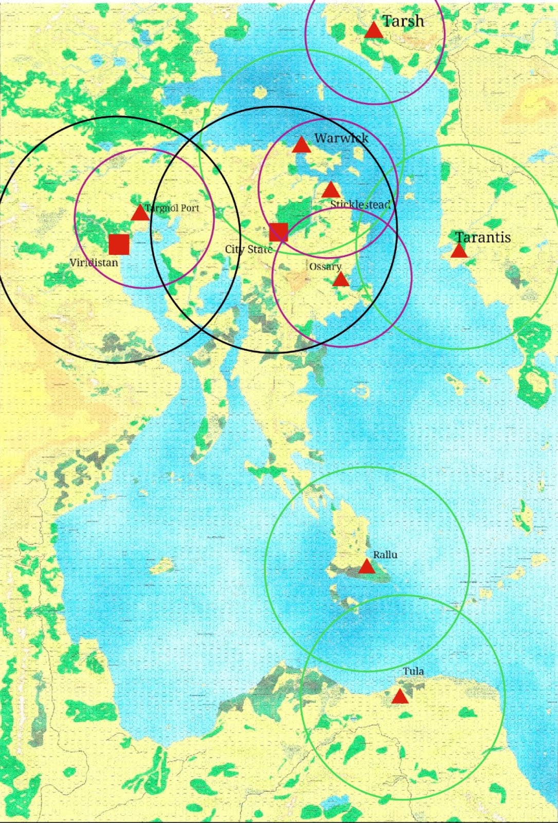
    I decided to use the classic City State of the Invincible Overlord and Wilderlands setting.  It will be an interesting exercise in working out conversions from Dungeons and Dragons to Chivalry and Sorcery - I don't recall ever trying it back when we were playing regularly.

     The most important NPC for a C&S character is their Master, who teaches them, sends them on errands and rewards them out of the loot they bring back.  After combing through the Wilderlands, CSIO and various supplements to determine the known NPC magick users, I started rolling dice and came up with Althelbrus the Affable, proprietor of the Sorcerors Supply House on Regal Street (Initial Guidelines Booklet I).  In D&D terms, Athelbrus is 6th level, which in C&S is too low to be a master, as you need a minimum concentration level of 75, which would be 9th level.  So to convert, I'll multiply the D&D Level by 25 to determine the C&S Concentration Level - 150, which places gives him an MKL in the 11-12 range.

     In terms of backstory, I like the fit.  Dyers would use some of the same materials that magic users use in making colored powders and smokes, so there is a reason why Athelbrus would know Mordacis.  I assume after the death of Mordacis' family, Athelbrus takes him on as a non-magical shop assistant.

     As a shop assistant in the Sorcerors Supply House, he will need to learn about all of the material components listed in C&S. (I have a penciled note from the 1970's on Page 73 of mine indicating that there are 265 Common Compounds.)  Under the section on Alchemists there are rules for learning about such things.  Even though he isn't an alchemist, I'm ruling that he receives an equivalent education to Conquest of the Common Metals I and Grasp of the Common Compounds.  Based on his intelligence, it will take him four months to learn everything about the twelve metals and (rounded up) another six months to learn the Common Compounds.  He's not an alchemist, so he will only receive experience for being a Magick User during this time.  When it comes to enchanting materials he will be able to use the rules for Alchemists for more rapidly enchanting the materials under Grasp of the Common Compounds.  Ten months of study at MKL 1, provides 303 Experience Points that I'll add to the previous total for learning the spells, that actually happened afterwards.  He's still 4000 odd XP below 4th level.

    Impressing Athelbrus with his quick learning ability and facility for languages, he is then taken on as an Apprentice Magick User and taught his first spell: Dispel Fatigue, as he tires so easily.

     Nineteen months and one week of game time after the character began, he is finally ready to begin adventuring.

    Languages - as he's gone up two levels, he has no less than 20 language points to spend.  Using my earlier work on the Languages of the Wilderlands, here's how he expended them to earn another even 1000XP.  He's in luck at this point, because so many languages are commonly in use in the City State, he can use all of the language points he earned.

2 points - read and write the Common tongue. C&S characters are not presumed to know how to read and write for the most part.
6 points - speak, read and write Orichalan, one of the languages of Magick.  Heavily used by Alchemists, it's the primary labeling system for the shop.
6 points - speak, read and write Draconic, the primary language of Magick scrolls and notes.  Secondarily used to describe metals and compounds.
1 point - Goblin.  He learns to communicate and direct the six goblin slaves Athelbur owns.
1 point - Tharbian.  One of the precursors to the Common tongue, used by peasants in the area, it has no written form.
1 point - Altanian.  One of the precursors to the Common tongue, used by nomads to the south who work in the City State as mercenaries, it has no written form.
3 points - Viridian.  Another precursor to the Common tongue, the only one with a written form.  Commonly used by the older nobility of the City State.


Mordacis


Human Male
Age 14


Level 3

XP
6732
5’ 1”
100 Dr


MKL 1


Characteristics

DEX
21
ST
9
CON
3
PA
12
BV
11
IQ
21
WIS
20
CHA
17
ALGN
13


Combat

Body
14
Fatigue
5
Carry Cap
70Dr
Military Ability
19
Command Level
10
PCF
7.0

Blows
Damage
%HIt
%Parry

Light Weapons
-
3*WDF
+10%
-10%

Heavy Weapons
_
3*WDF
+8%
-5%

% Shield Parry
N/A
Dodge
-10%


Social
Born William, son of Edmund, a journeyman dyer in the Clothiers Guild.  
He is a well aspected Pisces.  He lost his family at age 13 when his father’s 
experiments with a new mordant released a poisonous gas and left William with 
a weak chest (CON 3).  William took the 130 silver his father had saved and 
apprenticed himself to a local magick user.  He has since adopted the nom de 
magick of Mordacis, as an homage to his father’s profession.

Social Status
4
Basic Influence Factor
15.5
  Magick
While many of the Magical Modes would have benefited from his high 
Dexterity (Alchemist, Artificer), Intelligence (Cabala/Symbolist) or Wisdom
(Diviner, Necromancer), the Fates have declared that he practice as a
Power Word Magician despite having only an average Bardic Voice.

Concentration Level
4.7
Personal Magick Factor
21.3

Magick Level
1
Spell Level
1

Direct
Injurious
Effect
Volume
Multiplier
(Missiles)
Volume
Multiplier
(Material)
Time
Factor
Spell
Range
3*EDF
3*
8*
4*MKL
15’ *MKL

Languages: Common (RW), Viridian(RW), Goblin, Tharbian, Altanian
Magickal Languages: Orichalan (RW), Draconic(RW)

Spells:
Illusion - Dispel Fatigue (4+1d20 Turns)

Useful Skills:
Enchanting Common Compounds - reduces BMR by 40%+2% per MKL for
each enchantment spell successfully cast.

Local Knowledge - because of where he works, he has a 90% chance to
know any Magick User residing in the City State, at least by reputation if
not personal acquaintance. For Magick User NPCs on Map One residing
outside the City, the chance is reduced to 50%.

Identification of Non-Magical Materials - he is able to identify any material
from the tables of Common Compounds. For metals, if he has access to the
required equipment, he can assay metal and mineral samples to determine the
composition.