Showing posts with label Epirus Nova. Show all posts

Thursday, December 11, 2014

Building Campaign Maps with Google & GIMP 7 - Scodra takes shape, but doesn't gel

I've been playing around with GIMP again, wanting to start mapping the local area, especially the town of Scodra and the location of the Castle of the Mad Archmage (Gentius' Palace in the campaign).  While the techniques I documented in the previous posts (1, 2, 3, 4, 5, 6) on the subject work, I find myself scraping the bottom in terms of granularity of the image.

The technique I used was to drill Google Maps down to the highest magnification, remove modern features and replace them with features and names for the setting. I made extensive use of the Smudge tool to soften the edges of the areas I masked. So far so good,

The hexes are approximately 1 mile center to center, I've added the walls of the town roads and a latifundium centered on the twenty year old remains of the legionary camp (Castra Appius).  The black dot on the hilltop is the location of the Castle of the Mad Archmage, just outside of town.

I then selected the center of the image, moved it into a new xcf file and scaled it up by a factor of three.  I immediately noticed that the line I had added pixelated badly when they were blown up, but a little editing and running the Smudge tool over them helped with the appearance.

I then started laying out the interior of Scodra, starting with the king's palace and garden at the east end.  So far so good.  Then the street grid, and because the area is not aligned with the screen pixels, I ended up with jagged edges and blobs.  Not great, but reasonable.  Then I tried placing the 'Old Fish' by the gate - and even at the scale of this image it's visibly not parallel to the street grid.
Perhaps if I can increase the pixel density in the image or go back and blow up the image further, I can improve the quality.  Otherwise I'll leave off buildings and just note the contents of the block.
Not everything succeeds at the first try, the trick is not to be afraid to take the second try.

Wednesday, November 19, 2014

Calendars Old and New

The 1e DMG has a stern admonition on tracking time "YOU CAN NOT HAVE A MEANINGFUL CAMPAIGN IF STRICT TIME RECORDS ARE NOT KEPT."  Emphasis in the original

I never have.

In retrospect, part of it is the way my college group played - we did the modules and one shot adventures, never a mega-dungeon.  That type of episodic playing allows the group to hand wave the time accounting.  You adventure until you've cleaned out the local dungeon and then some undefined time later you're at the next dungeon having done your training and leveled up.  Don't get me wrong, it's nature and nurture that made me avoid doing the forensic accounting of strict timekeeping.  I don't want to fiddle with anymore paperwork than I have to, and as long I stick to running adventures for the group I can get away with not tracking time.

But now I'm running through Castle of the Mad Archmage, building a corner of my setting around it and time tracking has become important for determining when a room gets re-stocked and when background events occur.

Saturday, December 29, 2012

Who's got their back?

One of the (many) pieces missing from my campaigns has been the relationships between NPCs. Patrick Halter over at Renovating the Temple has a nice graphic of the relationships in the village of Hommlet, which has inspired this post in an elliptical manner.
     In my reading of classical history one of the things I've noticed is the importance of legally recognized tribal relationships in the political systems of both Athens and Rome.  Now, for whatever reason, I've always had a conception that  tribe was a social organization of blood relatives, this isn't necessarily the case in the classical world, as the Romans created brand new tribes several times during the Republic.  Layer on top of that the client-patron relationships cultivated by the Romans and you find that bilking that merchant just brought you the enmity of a whole slue of people. (By the way, this is still common in less developed {less socially mobile?} parts of the world, read about some of the troops experiences with local suppliers in Iraq.)
   Getting back to my point, along with generating an NPC's description, I'll need to generate their tribe and patron/clients.  Obviously minor NPCs don't need all the details, but I do need to have idea about who they can call on for support if the party gets out of hand.

   The diagram above lays out the relationships between the Roman hierarchy and the rulers in the area, along with other NPCs mentioned in 20 Questions.  Of importance to this discussion are the seven families who rule the city of Apollonia, where their characters will initially be based.  Most of the NPCs that the party will meet will trace a relationship to one of the seven families, or to their enemies as given in the table below.

Family Prominent Individuals Interests Allies Enemies
Paileos Aurelius, Archon of Apollonia Agriculture, Shipping Romans, Apistos, Trapezitos, Proskyntos Roz, Listeios, Emporos, Mith, Perseus Tuetella
Apistos Damon, Boule Agriculture Paileos, Proskyntos Trapezitos
Roz Aristarchus, Boule Agriculture, Shipping Listeios, Emporos, Mith, Romans Paileos
Listeios Taulus Listeios, Boule Agriculture, Ship Building Perseus Tuetella, Roz, Mith Romans, Paileos, Elos
Trapezitos Gauis Trapezitus, Boule Agriculture, Ship Building Paileos, Apistos Listeios, Elos
Proskyntos Epaphroditus, Boule Agriculture, Macedonian Trade Paileos, Apistos Roz, Emporos, Mith
Emporos Onesimus, Boule Agriculture Trapezitos, Listeios Paileos
Mith Hyllus Mith Illyrian and Macedonian Trade Romans, Listeios Paileos, Proskyntos
Geraki Asteropaios Metalwork Miraditorum, Mith, Proskyntos Perseus Teutella, Elos
Elos Cadmus Elos Asphalt, Ship Building Paileos Romans, Miraditorum, Geraki

With this back ground I can create Alcon the Smith.  A relative of the Proskyntos, when the players bring in some dwarf made armor for refitting, he'll pass the word to Epaphroditus who would like to break the Geraki monopoly on the dwarven trade.  This may lead to contact from Proskyntos or, if Asterpaios hears of it, an assassination attempt as the Geraki work to maintain their lucrative trade.

Note that all of this is invisible to the players, unless they decide that their characters would like to find out why the assassin was sent.  It however enables me, as the DM, to determine which factions will approach the players as the characters become more powerful and thus more valuable as allies, and which hold grudges against them.

Hmm, maybe I'll add a campaign customization to my NPC Generator to determine which family they are aligned with. 

Wednesday, December 26, 2012

Building Campaign Maps 6 - Encounter Areas


 Using the techniques I've already shown, adding layers and a grid, I'm going to add Encounter Areas to my map.  This will be a separate layer for my use rather than something for the players edification.  The first step is to add another layer name 'Encounter Areas'.  The key difference is that now I'm going to change the opacity of the layer, so that previous (lower) layers can be seen through what I draw on the new layer. 


The Opacity control is located in the Layers dialogue box. Here I've set it to approximately 25%, or conversely, what ever I draw will be 75% transparent.

The next step is to add a hex grid to this level, using the same settings previously used on the Grid layer.  The only exception is that I changed the line color to blue. With the Opacity reduced, that makes the superimposed hex grids look purple.

Then I just had to choose which natural features comprised and separated the Encounter Areas, and (tediously) filled in each hex in the encounter area with the Area Fill tool.


In the end I have twenty one encounter areas, in a cool looking map.


Wednesday, December 12, 2012

Building Campaign Maps 5

Having mapped the information known to the players, the next step is to flesh out the map with minor towns, villages and connecting roads.

First I create a new Layer "Minor_Features" to contain the information.  The next decision to make is how many minor towns and villages will there be?  First I'll draw a distinction between small towns and villages; small towns for this exercise are independent communities, while villages are dependent on a larger urban area for a market.  I'll site small towns, such as Claudina and Masio Scampa on the route of the Via Egnatia the same way I sited the large towns and cities. 

For villages, I'll steal an idea from Warhammer FRP, and generate a random number of villages around each of the cities and towns.  Warhammer FRP  used the rule 4d6 villages around a city, but they were looking at population centers over 10,000, whereas Apollonia and Epidamnus are in the 5,000 - 10,000 population range.  So I'll use 2d6 for them and 1d6 for Lissus and Lychnidus.

Siting the villages will be done with some random rolls, one to determine the direction on the hex grid, the next to give an approximate distance.  Then I'll look for a natural feature, such as a river or valley and choose a hex in that area.

Another random number gives me the first letter of the village name, from there I'll choose one from lists of Greek and Illyrian place names available online.

After plotting them on the Minor_Features layer, I'll use the Path tool in GIMP to draw dashed lines for trails between the villages and towns.  The final effort looks like this.


If you compare this map to the version in the previous post in this series, you'll notice that the major roads have been redrawn in black. I liked the effect of the Path tool, better than the hand drawn ones I had done earlier. Good thing I had the foresight to put them on a different level than the terrain, it made deleting them a breeze with no terrain to carefully rebuild like I did when I removed the modern infrastructure.

I still have all the villages in the southern part of the map to add and some more trails to this layer, but that's just finishing it off.  If I come up with a new technique I'll post about it.

Tuesday, December 11, 2012

Social Class and Influence

One of the longest screeds in the 1e DMG is about Social Class and why it's not included in the rules. Conversely, Chivalry and Sorcery devotes pages of fine print to determining your character's Social Class, Birth Rank and Influence.  RuneQuest modifies your Charisma score for learning Oratory, leading successful (or disastrous) expeditions and having "showy" magic items. I can see the point for all of these.

What does the dragon you're negotiating ransom with care that you're the third son of the Baroness of Crumpet?  Why isn't the innkeeper deferring to you because you are?  Why do you still have an 18 charisma after you led that disastrous foray against said dragon?

For Epirus Nova,  I'm leaving the basic Charisma score alone.  It reflects your force of personality that you can get across to any intelligent creature.  However I'm going to add an Influence modifier, that may be used when dealing with other members of society.  It's applicability outside of your character's society is at the DMs discretion.

The components of Influence are Citizenship, Social Status, Wealth and Success.

Citizenship 

A great differentiator in the Roman world, if I recall my Bible correctly, the Apostle Paul was able to avoid immediate execution in favor of being sent to Rome, because he was a Roman citizen.  The Grades of citizenship in descending order are  Roman - enjoying full legal protection; Latin - Full legal protection under Roman law, not allowed to marry Roman citizens; Socii - citizens of Roman allies with defined legal rights; Foederati - citizens of conquered and subsequently allied states and Provinciales - any one without defined rights, who is subject to Roman control or jurisdiction.  Now, the distinction I'm drawing between Socii and Foederati wasn't as clear cut as I have made it; but this way is easier from the standpoint of game mechanics,

Social Status 

In the Republic this was a matter of birth, wealth, family history and getting elected.  At the top of the heap was any one who who has Imperium, that is a legal power to command others with in the boundaries of their duties.  It exists in varying degrees that are not important to this discussion.  Usually it is held by an individual as a virtue of the office to which they have been elected, such as Consul.  Grants of Imperium could be tailored to the task on hand.  Pompey the Great received a grant of Imperium in all territories within 50 miles of the sea when he was tasked with suppressing piracy.  Anyone with Imperium has the power to impose capital punishment outside of Rome itself.  Usually, held by men of Senatorial rank, however Equites were occasionally elected to offices with Imperium.  Non-Roman kings and tyrants are at this level.

Below holders of Imperium, comes the Senate.  There are two classes with in this category, regular and Nobles.  Noble Senators either had held a Consulship or had an ancestor who had been a Consul.  The minimum property qualification for a Senator is 1,000,000 GP.  this is anachronism, the requirement of 1,000,000 sesterces didn't come about until the Empire and the sesterce was a small silver coin.  Again, game mechanics.  Non-Roman oligarchs, upper and lower nobility.

Below the Senate are the Equites or 'Horsemen', they have a minimum wealth of 400,000 GP.  Non-Roman knights.

Not quite at the bottom are the Plebs, or commons.  With game mechanics in mind, I'm sub dividing these into Plebs who meet wealth thresholds, then Plebs who are clients of someone higher in the social order and unaligned Plebs.  The Patron/Client relationship was very important in the Roman society.  Having a patron meant you had a friend in court, some one who could loan you money, in return for which you provided political support and attended on them in public functions.  Of course, if you had the money yourself, you could function as a patron yourself.

Below the Plebs are the Freedmen and finally the Slaves.

Throwing it into a table:


InfluenceRomanLatinSociiFoederatiProvinciales
10Imperium
9Senator - NobleImperium
8SenatorSenator - NobleImperium 
7EquitesSenatorSenator-NobleImperium
6Pleb 300K gpEquitesSenatorSenator-NobleImperium
5Pleb 200K gpPleb 300K gpEquitesSenatorSenator-Noble
4Pleb 100K gpPleb 200K gpPleb 200K gpEquitesSenator
3Pleb 40K gpPleb 100K gpPleb 100K gpPleb 200K gpEquites
2Pleb 20K gpPleb 40K gpPleb 40K gpPleb 40K gpPleb 200K gp
1Pleb - ClientPleb - ClientPleb - ClientPleb - ClientPleb - Client
0Pleb Pleb  Pleb  Pleb  Pleb 
-1FreedmanFreedmanFreedmanFreedman
-2SlaveSlaveSlaveSlaveSlave

Wealth

As discussed under Senators and Equites, there are minimum levels of wealth to join the upper classes.  Of course, it's not automatic that they'll let you join.  You'll need to convince the Censor (a politcal office held by a Senator) that they should add you to the rolls.  Within the Plebs wealth is used to determine the pecking order.

Success  

Achieving a publicly acclaimed success is good for 1 point of Influence.  From a game mechanics stand point success is recovery a treasure worth more than 1000 GP x Average Party Level x Size of Party (including NPCs) or defeating a single monster which has Hit Dice equal or greater than Avergae Party Level + 4.

Failure

The converse of Success, a notable failure will cost one or more points of Influence.  In game play, each expedition where characters or NPCs do not return will cost an Influence point for each death - unless the Expedition was a Success.  Failure to complete an assignment for a Patron, will cost a point of Influence.

Using Influence

Influence can be used to modify the initial die roll when interacting with NPCs.  In those cases where failure allows a re-try, Influence can not be used on the re-tries.  If they weren't impressed with you the first time, they they'll completely discount it subsequently.

Have they heard of me?

The check to see if a particular NPC or group of NPCs has heard of the characters is 20 - the highest Influence in the party.  Similarly, to see if a character is recognized by an individual, the check is 20 - the character's Influence.  Not a good thing for an active Rogue to be picked out of a line up.

Friday, December 7, 2012

Building Campaign Maps with Google and GIMP 4

Cities, Rivers and Mountains

   As I showed in the previous post in this series,  I've added a layer which I've added a layer named "Player_Knowledge" to the xcf file.  On this layer, I'll site the large towns and geographic features that the players will know about when they arrive.

     The first question I need to answer is - what do they know about?  For my primary source of information, I'm going to use Strabo's Geographica (See Appendix N) Book 7, Chapters 5 (Illyria and Pannonia) and Chapter 7 (Epirus).  Fortunately, the footnotes embedded in the translation give the modern names for the cities and features, well modern as of 150 years ago.  Anything that I can't google, I'll use Smith's Dictionary of Greek and Roman Geography (Appendix N)  to find an intermediate place name.

Throwing it into a table we end up with.

StraboModernNotes
River DriloDrin
Lissa (Lissus)LesheAlso known as Alesso.  Large town.
AcrolissaNot a town, but a reference to the citadel  at Lissus.  I'll use that piece of information and declare that it's a legionary or at least an auxiliary fort protecting the area against the Illyrian tribes.
EpidamnusDurresBy Strabo's time the Romans had started calling it 'Dyrrachium' after the promontory, as the Greek name had inauspicious overtone in Latin. Small City.
River AspusSeman
River AousVjoseApollonia is situated about a mile from it.
Apollonia DestroyedThe only remains of Apollonia are part of the Temple of Apollo on the hill. Small city.
Mons CandaviaShebenikSearching Smith's, it's located on the road from Epidamnus to Lychnidus.  The biggest mountain along the way is Shebenik.
LychnidusOhridOver the border into Macedonia. Small town.
Pylon UnknownAs this marks a Roman boundary, I'm ruling that it hasn't been determined at this point.  Determining the boundary may become part of the campaign.
Mons CeraunMal i KanalitDerived from the Greek 'Thunder Split Mountain' - sounds like an adventure location to me.
OricumOrikum Small town.
Panormus (harbor)The Pasha's HarborThe harbor for Oricum
OnchesmusSarandeHad to chase this one through Smith's to 'Forty Saints' to Sarande. Large Town
CassiopaeKassiopiActually on the coast of the island of Corfu. Looking at the map, it's just off the southern boundary, so I'll skip it.


By using the Modern names, I was able to place the cities and towns on the map.

 I had said that the names showed up as mini-layers in GIMP.  I have since found that I can 'Merge Down' the mini-layers  into the lower level, so I now have them all in the Player_Knowledge layer.

The gray line represents a known major road.
That pretty well wraps up adding the historical elements onto the basic map.  I still need to generate smaller towns and villages, as well a do overlays for encounter areas, mask the interior so I can save off a view for my players, with out them knowing which valley they need to go up to get across the mountains.  I'm also toying with laying out  the areas for the different tribes, but haven't decided on that step yet.

Thursday, November 29, 2012

Building Campaign Maps with Google and GIMP 3

Ridiculously easy

In the previous post, I had finished editing out all of the roads and labels leftover from the screenshot I had taken in Google Maps.  I want a hex map, I came up when players still bounced routinely between RPGs and Avalon Hill or Strategy and Tactics' board games, all of which were overlayed with a hex grid. I 've tried generating hex grids on computers for thirty years with varying results.  Here I go again.

Start by saving the map as a GIMP *.xcf, that way even if you screw up down the line, there's a back up of all that work you put in to clean up the terrain.  With the xcf file, I'm going to add layers, that way if I put a town in the wrong place, I won't have to re-edit the terrain.  To do that, press Control-L to bring up the Layer dialog. 


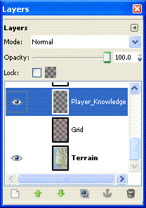
I've gone into the Layer Properties and renamed the first layer as 'Terrain', and created two additional layers 'Grid' and 'Player_Knowledge'.  I'll use the latter to control what shows up on any maps I provide to the players.  The little eye icons, control visibility of the layer, 'Grid' is currently invisible.  The highlighted layer indicates which one you are currently editing.

As expected the page icon in the lower left is used to create a new layer.


So, how about that grid. I did a quick Google search in the expectation that someone, somewhere had not only wanted to use GIMP to make a hex grid, but had published direction on how to do it.  What I found was a GIMP 'Script-fu' to do it for me - Hex Grid. Follow the instructions to install the script, then select your Grid layer and Filters->Render->Pattern->Hex Grid.
Change the color to red, reduce the Line Width to 1 pixel and throw in a horizontal offset of half a pixel to avoid edge effects.  A little playing around counting hexes demonstrated that a Side length of 9 pixels gives a scale of approximately one mile center to center on the hexes. I'm not going to worry about the exact scale, (a) I'm limited by technology, I can't make it draw fractions of a pixel, (b) in the Classical world they couldn't agree on the length of measurement either, and (c) it's a play aid, close enough works.

Here's the map from Apollonia to Oricum at 1:1 scale.  I'm also showing the Player_Knowledge layer with the cities and major roads.  Oddly, to me anyway, each name is treated as a separate 'mini-layer' by GIMP, so looking in the Layer dialogue you will also see Layers for 'Apollonia' and 'Oricum'.


As I said at the beginning it's ridiculously easy to add a hex grid in GIMP for tracking overland travel.  In a subsequent post I'll cover how I sited the cities, and start generating smaller communities on a 'Small_Town' layer.

Wednesday, November 28, 2012

20 Questions

My answers to Jeff Rients 20 Questions. Campaign map at the bottom.

  1. What is the deal with my cleric's religion?
    It's all politics at the top. Powerful individuals get elected to the position of high priest for the social status it brings them. They can do a few divinations, but don't ask them to raise the fighter from the dead. The heavy lifting is done by under priests, who often retired/crippled adventurers such as your character. The good news is that if you can help the high priest, he'll help you. Whether it's straightening out that little mix up that burned the tavern down or knowing where to get that rare Egyptian unguent needed for the potion, the high priest has the connections to help.

  2. Where can we go to buy standard equipment? 
    Lissus, Epidamnus, Apollonia can supply you with most of what you want. In particular, Apollonia and Epidamnus are major trading ports on the route to and from Italy and the East. Goods are periodically available in those locations that are usually only available in larger cities. Lychnidus, Oricum and Onchesmus have most standard goods for sale, rarely a single masterwork item. Smaller villages will only have provisions and mundane items.

  3. Where can we go to get platemail custom fitted for this monster I just befriended? 
    Sucks to be you. Platemail hasn't been invented yet, nor has half plate. The best you will do is Banded. I'd start with the armorers at the Cohort IXof Legion I Macedonicus in Lissus

  4. Who is the mightiest wizard in the land? 
    Pantarious, as the Egyptian Pan-Twa-Re's name has been latinized. A recent arrival with the new Legate G. Servilius Vatia in Apollonia.

  5. Who is the greatest warrior in the land? 
    Lucius Pulcio, retired Roman soldier now serving as Captain of the Guard for Perseus Tuetella, Dynast of Epidamnus. Pulcio single handedly killed an elephant charging his cohort at the battle of Zama, receiving a Civic Crown for his achievement.

  6. Who is the richest person in the land?
    The Legate G. Servilius Vatia is only here temporarily, so Perseus Tuetella, Dynast of Epidamnus is the richest local.

  7. Where can we go to get some magical healing? 
    Apollonia is your best bet, the Temple of Apollo has an attached shrine to his son Asclepius. Also, you can try the Stoa of Apollonia, a group of mages and sages who are willing to try anything to cure someone else.

  8. Where can we go to get cures for the following conditions: poison, disease, curse, level drain, lycanthropy, polymorph, alignment change, death, undeath? 
    The Stoa of Apollonia

  9. Is there a magic guild my MU belongs to or that I can join in order to get more spells? 
    No guild, but you can buy temporary library rights from the tutors at the Stoa.

  10. Where can I find an alchemist, sage or other expert NPC? 
    The Stoa of Apollonia for intellectuals.  Lissus, Epidamnus and Apollonia for skilled craftsmen.

  11. Where can I hire mercenaries? 
    Lissus, Epidamnus and Apollonia have ruffians for hire. Not really trained mercenaries, but sailors who like to fight.

  12. Is there any place on the map where swords are illegal, magic is outlawed or any other notable hassles from Johnny Law? 
    Illegal, no. But anything bigger than a shortsword and leather armor gets you marked as a barbarian within the towns. In other words, prices go up and reactions go down (-2).

  13. Which way to the nearest tavern? 
    The upper class entertain each other in their own houses. So all you'll find are neighborhood bars, where prices will go up and reactions down (-2) to strangers, or dives down by the waterfront. 

  14. What monsters are terrorizing the countryside sufficiently that if I kill them I will become famous? 
    Nothing near the cities, and anything done up in the mountains will be discounted as occurring in out in the sticks.  You might want to hire someone to write an epic poem about your feat, if fame is that important to you.

  15. Are there any wars brewing I could go fight? 
    Legion I Macedonicus Cohort IX in Lissus is hiring. It's a twenty five year hitch, roll up a new character. Tribal raids from the Illyrians are an occasional annoyance, but haven't gotten past the fortress at Lissus in over twenty years.

  16. How about gladiatorial arenas complete with hard-won glory and fabulous cash prizes? 
    Epidamnus. Minimum ten fights, hard to win - yes,  for glory and cash go to Rome.

  17. Are there any secret societies with sinister agendas I could join and/or fight? 
    Not so much secret societies, but people with agendas include Perseus Tuetella, Dynast of Epidamnus, who would like to kick the Romans out and set up the Illyrian kingdom again.  Also, the magician Pantarious is known to have his own agenda, but rumor doesn't agree on what it is.

  18. What is there to eat around here?
    Fish, Goat, Olives, Fruit, Grains.  Wine in the low lands, beer is more common in the mountains.

  19. Any legendary lost treasures I could be looking for? 
    Jason's Shield, that he used to defeat Medusa, is said to be hidden in the mountains.  It is said to be the first object made out of Bright-Steel by the Miraditorum dwarves.

  20. Where is the nearest dragon or other monster with Type H treasure?
    A large bronze dragon has been seen along the coast south of Oricum.
Here's the map with the cities shown.  How I went from the terrain to adding in cities and major roads is a subject for another post.


Building Campaign Maps with Google and GIMP 2

Removing labels, roads and borders

In my last post I had taken an image from Google maps and trimmed off the unwanted borders.  Now for a few techniques in taking the map down to just the terrain.


Here I've taken the previous image and zoomed to a 4:1 scale (400% actual size).  I've found this is the largest scale where I can still recognize the terrain while I'm editing. I'm going to remove the label "Kolonje" in this example, it will demonstrate the technique I use to rebuild land forms that were covered by labels.

Use the eyedropper tool (1) to select the lightest color from the surrounding terrain.  The use the paint brush tool (02), set on a convenient shape, such as "Circle (05)" (3) to paint over the lablel (4).


`
The next step is to use the spray gun tool to rebuild terrain features.  This time select the darkest portion of the feature being rebuilt with the eyedropper and set the spray gun tool to "Fuzzy Circle (03)", this allows the paint to fade out at  the edges.  Draw in the lines you want and then darken the intervening spaces to match the surrounding terrain.


 The last step is to use the eyedropper to select the color of the surrounding terrain and paint over the rest of the label and any roads or other symbols in the area.


Repeat for all the other labels until your map is clean.  It will take several hours, but in the end you'll end up with a map like this.  (In this map, I've stitched together the areas above and below the initial map to build a map of the campaign area).


Tuesday, November 27, 2012

Building Campaign Maps with Google and Gimp

My campaign has been in hiatus for a few months now while I've been playing Alesmiter; so my batteries are recharged and I'm ready to start planning the next round of adventures.  One of the decisions I've made is to move the campaign location from North Africa to Eprius Nova, the area which we now call Albania.  It gives me adventuring areas closer to an urban center.  Time to make a new map.

I'm using a new technique to make the maps, snapshots of Google maps areas, cleaned up and stitched together using GIMP.  I'm not a GIMP expert by any means, but I've been able to figure out how to do things with it fairly easily.  I'm running a campaign set in a fantasy Roman Republic, just after the fall of Carthage and about 90 years before Gaius Julius Caesar invades Gaul.  So Google Maps can be used to build my campaign world.  Of course, any large scale (small area) fantasy setting could be mapped over piece of the real world terrain using these techniques.

Getting the image - I opened Google Maps to Albania at the 5 mile scale and took a snapshot on my tablet.
I saved the image off onto my laptop and opened it in GIMP.

I used Google Maps - Terrain mode because it gives me an effect I like better than the plain Satellite view or the Earth view.  It does have a limitation in that I can't turn labels off in this view.  So I'll have to deal with them later.  The first thing I'll do is crop the control bars on the top and bottom of the image. 

The cross hairs on the pointer (not shown) identify a point on the image, by hovering over the top of the lower control bar, the pointer location circled in the bottom corner of the screen shows that it's at pixel 752.  Similarly I used the pointer to find the bottom of the top control bar, at pixel 58.  752 -58 gives us an image height of 694.


 Using Image -> Canvas Size from the menu I reach this dialog


Click on the chain icon (1) to decouple the image Width and Height, as we don't need to trim the ends.  Set the desired image height (2).  Set your offset from the top of the image (3) - not sure why the value '58' didn't get captured here.  Select to resize All Layers (4), click Center (5) and then Resize (6).  And you have successfully trimmed your image.


In my next post I'll cover techniques for getting rid of those pesky labels, modern roads and borders from the image.